


First developed by the United States military, the Global Positioning System (GPS) relies on a network of satellites and synced atomic clocks to provide positioning, navigation, and timing (PNT) services. There are three components or elements that make the system work for individual users: 1) the space segment, 2) the control segment, and 3) the user segment. The first two of those three segments are the responsibility of the United States Air Force. In this article, we will take an in-depth look at what are the 3 elements of GPS and answer all your questions about the principles of GPS. Let’s dive in.
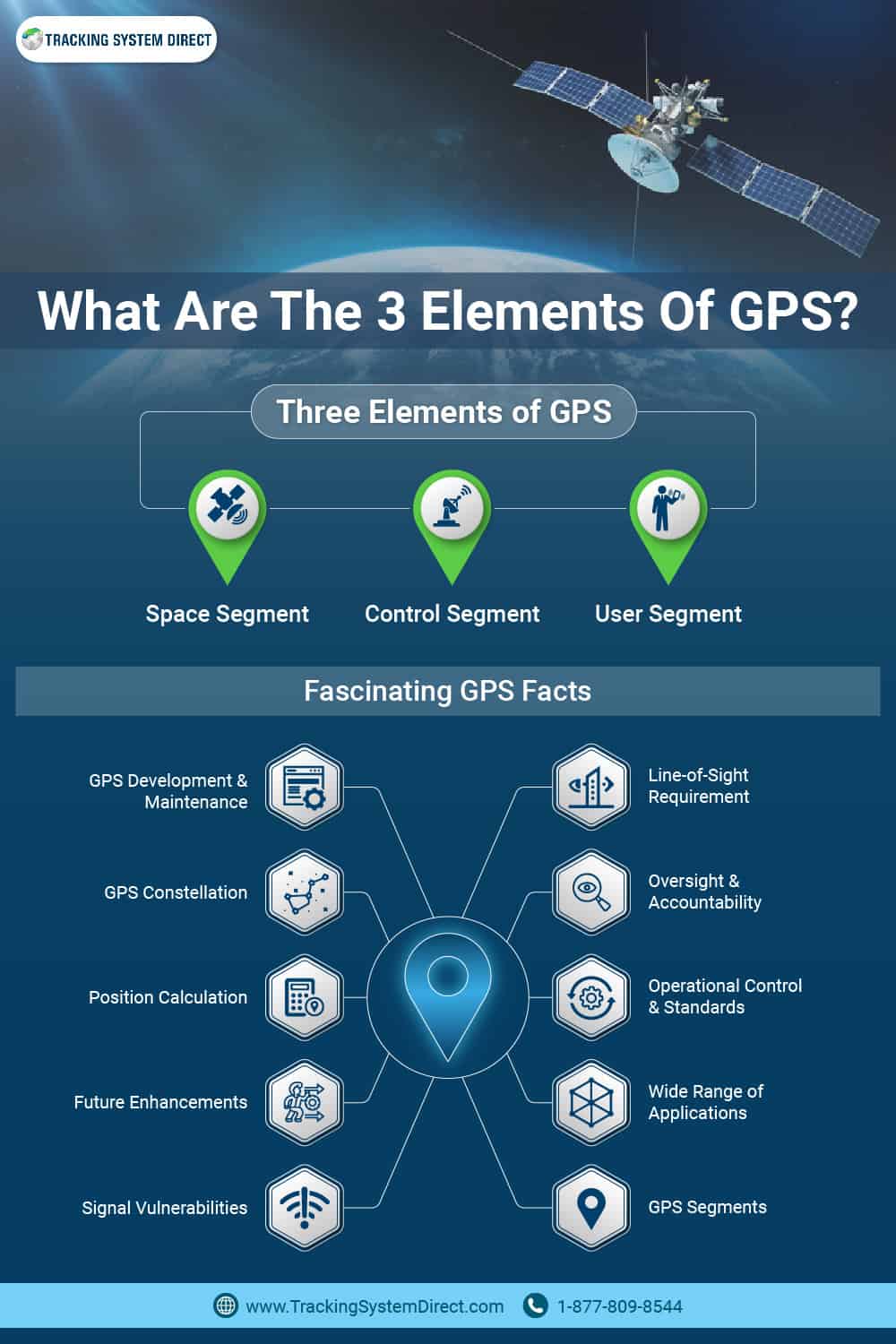
The space segment of GPS is composed of a constellation of at least 24 GPS satellites that orbit the Earth at an altitude of about 20,200 km, in six orbital planes inclined at 55 degrees with respect to the equator. The satellites operate in Medium Earth Orbit (MEO) and continuously transmit signals to GPS units on the ground. Each satellite orbits the Earth twice a day and is equipped with atomic clocks, which are essential for providing accurate timing and positioning information.
GPS satellites use a variety of methods to transmit signals, including spread-spectrum techniques that make the signal difficult to jam or interfere with. The carrier waves transmitted by the satellites are modulated with the navigation message, which contains data on the satellite’s position, velocity, and time. The navigation message is broadcast in two formats, the Coarse Acquisition (C/A) code and the Precision (P) code, which provide different levels of accuracy and security. The satellites also transmit a military-specific signal, known as the M code, which is encrypted and provides enhanced security.
The satellites in the GPS constellation are maintained by the United States Space Force, which has the responsibility of launching new satellites, replacing malfunctioning satellites, and ensuring the overall health and functionality of the constellation. To maintain the accuracy of the GPS system, the satellite clocks are regularly monitored and adjusted using a technique known as Satellite Laser Ranging (SLR). SLR involves firing laser beams from ground-based stations to the GPS satellites and measuring the time it takes for the beam to be reflected back. This allows precise measurements of the satellite’s position and velocity, which are used to correct any clock drift.
The Control Segment is responsible for managing and maintaining the GPS satellites and ensuring the accuracy and integrity of the GPS system. It is composed of a network of ground-based stations, which includes a master control station, four ground antennas, and 16 monitoring stations located around the world.
The master control station, located at Schriever Air Force Base in Colorado, is responsible for monitoring and controlling the GPS satellites. The master control station monitors the health and performance of the satellites, updates their orbital parameters, and manages the upload and download of data to and from the satellites. Additionally, the master control station manages the GPS constellation and the timing and navigation messages transmitted by the satellites.
The ground antennas, located in Hawaii, Colorado, Ascension Island, and Kwajalein Atoll, are responsible for transmitting signals to the GPS satellites to update their orbits and upload new data. The antennas are equipped with powerful transmitters capable of transmitting signals to the satellites at a power of up to 750 watts.
The monitoring stations, located around the world, are responsible for tracking the GPS satellites and monitoring the timing and navigation messages transmitted by the satellites. The monitoring stations use a technique called Satellite Laser Ranging (SLR) to precisely measure the satellite’s position, which is used to correct any orbital errors.
The Department of Defense (DoD) operates the Control Segment through its Operational Control System, which ensures that the GPS system is maintained according to performance standards. The DoD has established a Performance Standard for GPS that defines the minimum levels of performance required for the GPS system. The standard covers a variety of areas, including accuracy, coverage, reliability, and security.
What you should know is that the Control Segment is a critical component of the GPS system that ensures the accuracy, reliability, and security of the GPS system. The Control Segment is responsible for monitoring and controlling the GPS satellites, uploading new data to the satellites, and maintaining the GPS constellation. The Performance Standard for GPS established by the Department of Defense ensures that the GPS system meets the minimum levels of performance required for its various applications.

User Segment -GPS Receivers and Differential GPS
The User Segment of GPS is the portion of the system that includes the GPS devices that individuals and organizations use for navigation and tracking purposes. GPS vehicle tracking devices, or GPS receivers, receive signals from GPS satellites and use them to calculate the user’s position and velocity.
GPS receivers work by comparing the time difference between the signals received from at least four satellites and using that information to calculate the receiver’s position in three dimensions. The receiver determines the time it took for the signal to travel from the satellite to the receiver by comparing the time the signal was transmitted by the satellite to the time it was received by the receiver. The receiver then calculates the distance between the satellite and the receiver by multiplying the time it took the signal to travel by the speed of light. This process is repeated for signals received from at least four satellites, allowing the receiver to triangulate its position.
GPS receivers can be found in a wide range of devices, from smartphones to car navigation systems to wearable fitness trackers. These devices use different levels of accuracy and functionality depending on their specific applications. For example, a smartphone GPS may have an accuracy of about 5-10 meters, while a high-precision GPS used for surveying applications may have an accuracy of a few centimeters.
The User Segment also includes Differential GPS (DGPS), which improves GPS accuracy by using ground-based monitoring stations to correct for errors caused by factors like atmospheric conditions or satellite clock drift. DGPS works by comparing the GPS signal received by the GPS receiver with the signal received by the ground-based monitoring station. Any difference in the two signals is assumed to be an error, which can then be corrected to improve GPS accuracy.
To sum up, the User Segment of GPS includes GPS receivers used by individuals and organizations for navigation and tracking purposes. These receivers rely on signals transmitted by GPS satellites to calculate the user’s position in three dimensions.
Moreover, the User Segment also features Differential GPS, which uses ground-based monitoring stations to correct errors and improve GPS accuracy. Differential GPS compares the GPS signal received by the GPS receiver with the signal received by the ground-based monitoring station, and any difference in the two signals is assumed to be an error that can be corrected.
As a result of its accuracy and versatility, GPS has become an indispensable tool for various applications, including fleet management, outdoor recreation, and many more. The User Segment of GPS plays a critical role in making GPS technology accessible to a wide range of users, and its widespread adoption has transformed the way people navigate and track their locations.
![]()
10 Fascinating Facts About GPS You Never Knew!
- GPS was developed and maintained by the United States government.
- GPS is comprised of three segments: the Space Segment, the Control Segment, and the User Segment.
- GPS uses at least four satellites to calculate the user’s three-dimensional position.
- GPS signals can be jammed or disrupted by deliberate interference or natural obstructions.
- GPS requires line-of-sight access to at least four satellites for accurate positioning.
- The GPS constellation consists of 31 operational satellites in orbit.
- The GPS program is overseen by the U.S. Government Accountability Office (GAO).
- The Aerospace Corporation is responsible for GPS’s operational control and performance standards.
- GPS tracking technology is used in a wide range of applications, including fleet management and personal navigation devices.
- The future of GPS includes enhancements to the Global Navigation Satellite System (GNSS), such as the European Galileo system and the Chinese BeiDou system.
How Many GPS Systems Are There?
Department of Defense GPS Constellation
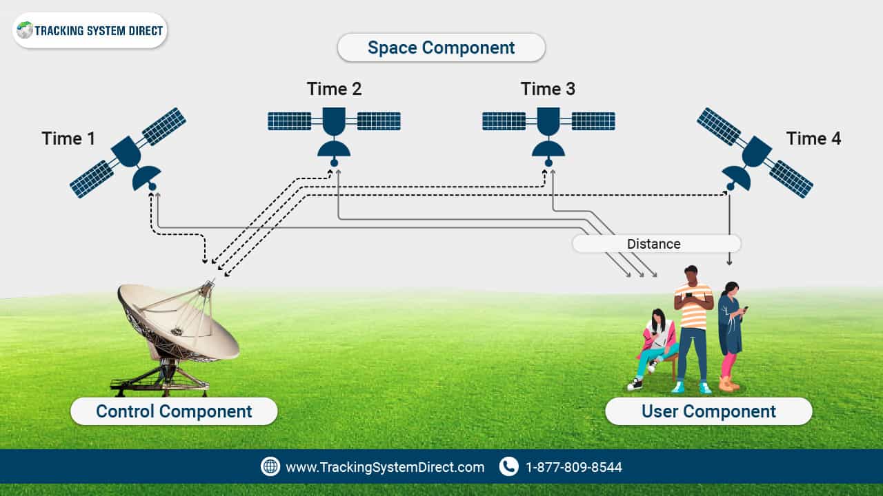
The space component or segment is the satellite arm of the system, utilizing a minimum of 24 orbiting and operational satellites. Each of these satellites transmits a one-way radio signal that included an encoded sequence relating to the atomic clock time; the one-way radio signal also includes information about the current GPS satellite position.
The control component or segment is the worldwide system of monitoring and control stations that help maintain satellites in their proper orbits, including making any clock adjustments or orbit manipulations. These command centers track each of the satellites, upload navigational data as it is freshly updated, and maintain the health and status of the constellation. These are critical components of GPS that assist with precision timing and time difference.
Finally, the user segment is your end and consists of GPS receiver equipment. Your GPS receiver takes the one-way radio signal from the satellite and uses that transmitted information to determine the distance from each satellite. Using a method known as trilateration (which we’ll discuss in greater detail in just a moment), the receiver can then determine location information for positioning and navigation purposes. Your GPS receiver can also use satellite info to determine the time. Your hiking GPS tracker will utilize each of those functions to help keep you from getting lost.
Even better, all three of these components and the services they enable have been available for civilian service, which is available freely and continuously all over the world since the Selective Availability Act. Additionally, some applications are available that can help augment GPS systems and techniques.
GPS User Equipment Velocity And Timing
Have you ever wondered how a GPS device provides exact longitude, latitude, position, and time? A GPS user equipment (whether it be GPS tracking or GPS navigation solution) receives satellite signals with ground antennas. The low-level radio signals from satellite constellations determine your position on Earth, arrival times, speed, altitude, and other data that can be helpful in vehicle tracking and additional consumer/business applications.
Related Content: https://www.trackingsystemdirect.com/best-real-time-gps-tracker/
Frequently Asked Questions
What Is GPS And What Are Its Main Uses?
GPS, or Global Positioning System, is a satellite-based navigation system that provides users with precise location, speed, and time information. The main uses of GPS include navigation, mapping, surveying, tracking, and timing. GPS is used in a variety of industries, including transportation, agriculture, construction, and emergency services.
How Many GPS Satellites Are In Orbit And How Do They Work Together?
There are currently 31 operational GPS satellites in orbit, arranged in six orbital planes, with at least four satellites in each plane. The satellites work together to provide continuous coverage of the Earth’s surface, allowing users to access GPS signals from anywhere on the planet. The satellites transmit signals that are picked up by GPS receivers on the ground, which use the signals to calculate the user’s position in three dimensions.
What Is Differential GPS And How Does It Work?
Differential GPS is a technology that improves the accuracy of GPS signals by using ground-based monitoring stations to correct errors. Differential GPS works by comparing the GPS signal received by a GPS receiver on the ground with the same signal received by a monitoring station located nearby. The monitoring station calculates the difference between the two signals and transmits correction data to the GPS receiver, which uses the data to improve the accuracy of its calculations. Differential GPS is commonly used in applications that require high accuracies, such as aviation, surveying, and precision agriculture.
Trilateration: How Does GPS Work?
If it helps, think of your receiver as the center of a three-circle Venn diagram. When your receiver gets a signal from a satellite, it can calculate the distance to the satellite, helping draw a circle of all possible locations that distance from the satellite. When you add the signal from a second satellite, you suddenly have a couple of intersection areas. A third satellite helps narrow it down further yet, and a fourth helps ensure that you also know the elevation data of the point at which you are currently located. That’s obviously a gross oversimplification, but you get the general idea of how GPS works in your hiking GPS tracker.
How Does The Control Segment Of GPS Ensure Accuracy And Integrity?
The Control Segment is responsible for maintaining and monitoring the GPS satellites, uploading new data to the satellites, and ensuring the accuracy and integrity of the GPS system. The Control Segment does this by regularly sending correction data to the satellites, synchronizing their clocks, and monitoring their orbits and signals for any issues or anomalies.

- Best Car GPS Tracker - October 25, 2023
- How GPS Works - October 8, 2023
- Who Invented GPS - October 6, 2023
Contents
