


Reading & Understanding GPS Coordinates- A Step-by-Step Guide
Upon first encountering a pair of GPS coordinates, you might feel some confusion when looking at the array of degrees and decimals. This reaction is totally understandable given the complexity of the geographical lines known as latitude and longitude that underpin these coordinates. In this article, we are going to go over how to read GPS coordinates in an effort to help clear up this confusion. With just a basic understanding of these geographical concepts, you’ll soon navigate through all three GPS coordinate formats with ease. Now, lets start by going over the importance longitude and latitude before moving on to the three GPS coordinate formats!
Understand Latitude and Longitude

Latitude
Latitude lines, often visualized as running horizontally, circle the Earth parallel to the Equator. These lines are crucial because they indicate how far north or south you are from the Equator, measured in degrees. Think of the Equator as the starting point, marked as 0 degrees. From there, latitude increases up to 90 degrees both north and south. Locations at 90 degrees North are at the North Pole, and similarly, 90 degrees South is at the South Pole.
Why does this matter for reading GPS coordinates? Knowing a place’s latitude gives you its position along the north-south axis of the Earth. This information is vital because it helps determine climate, time zones, and even the likelihood of seeing the Northern or Southern Lights. When you’re navigating, understanding latitude ensures you’re moving along the correct vertical path on the globe.
Longitude
Longitude lines run vertically around the Earth, intersecting at both the North and South Poles. These lines indicate how far east or west a location is from the Prime Meridian, which is designated as 0 degrees. The Prime Meridian runs through Greenwich, England, serving as the reference point for longitudinal measurement.
Longitude is essential for reading GPS coordinates because it determines a location’s position on the Earth’s east-west axis. This helps in navigation, ensuring you’re on the right horizontal path to your destination. Longitudinal information is critical not just for global positioning but also for time zone calculations, making it indispensable for accurate GPS reading.
With both latitude and longitude, you can pinpoint any location on Earth. This grid system of coordinates allows GPS devices to provide precise navigation instructions. Understanding the basics of latitude and longitude is the first step in demystifying how to read GPS coordinates. This knowledge empowers you to navigate confidently, whether you’re exploring unfamiliar cities or venturing into remote wilderness areas.
The 3 GPS Coordinate Formats: DMS, DMM and DD
In this section, we focus on the three main GPS coordinate formats: Degrees, Minutes, Seconds (DMS), Degrees and Decimal Minutes (DMM), and Decimal Degrees (DD). Understanding these formats is key to accurately reading GPS coordinates. Each format offers a different way to pinpoint locations, catering to a range of needs. By getting familiar with DMS, DMM, and DD, you’ll gain the foundational skills to read GPS coordinates effectively, setting the stage for mastering navigation techniques.
Degrees, Minutes, Seconds (DMS)
The Degrees, Minutes, Seconds (DMS) format is a cornerstone of geographical navigation, tracing its origins back to the early days of exploration. This format is highly precise, breaking down the Earth’s surface into degrees, minutes, and seconds to offer a detailed representation of location. Here’s a closer look at each component:
- Degrees (°). The starting point of the DMS format. Degrees represent the largest unit of measurement in this system, with the Earth’s circumference divided into 360 degrees. This division helps in denoting the distance from the equator (for latitude) or the Prime Meridian (for longitude).
- Minutes (‘). Each degree is further divided into 60 minutes. A minute of latitude or longitude represents 1/60th of a degree. This allows for a finer breakdown of the geographical position, enhancing the detail beyond the broad strokes provided by degrees alone.
- Seconds (“). For an even more precise location, each minute is divided into 60 seconds. This division offers a high level of detail, essential for pinpointing specific locations on the Earth’s surface.
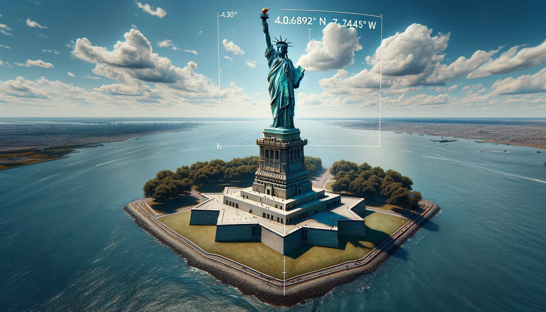
An example to illustrate the DMS format is the GPS coordinates of the Statue of Liberty, which are approximately 40° 41′ 21″ N, 74° 2′ 40″ W. This means the statue is located 40 degrees, 41 minutes, and 21 seconds north of the Equator, and 74 degrees, 2 minutes, and 40 seconds west of the Prime Meridian.
The DMS format is favored in contexts requiring high precision and is commonly used in mapping, navigation, and surveying. Why? Because its detailed breakdown into seconds allows for pinpointing locations with a high degree of accuracy, making it indispensable for certain navigational and geographical analyses.
To learn more about the DMS format and how to use it effectively, please visit U.S. Geological Survey’s website here: https://www.usgs.gov/
Degrees and Decimal Minutes (DMM)
The Degrees and Decimal Minutes (DMM) format strikes a balance between precision and simplicity. It’s a blend of the Degrees, Minutes, Seconds (DMS) system and Decimal Degrees (DD), marrying traditional navigation with modern convenience. In DMM, we still use degrees and minutes, but we simplify by converting seconds into a decimal fraction of a minute. Here’s the structure:
- Degrees (°): Like in DMS, degrees indicate the broad geographical position either north or south of the Equator, or east or west of the Prime Meridian.
- Decimal Minutes (‘): Instead of further dividing minutes into seconds, we express the fraction of a minute in decimal form. This method retains precision while simplifying calculations and data entry.
An example in DMM could be 40° 41.35′ N, 74° 2.667′ W. The decimal points (.35 and .667) represent the fraction of a minute, making the format more straightforward to read and use, especially in digital systems.
DMM is especially useful for those who require a balance between the detailed precision of DMS and the simplicity of DD. Therefore, it’s widely used in marine navigation, where quick, yet accurate, readings are crucial. Additionally, many GPS devices offer settings to display coordinates in DMM, making it a versatile choice for travelers and professionals alike.
The adoption of DMM reflects a move towards easier digital input while maintaining enough detail for accurate geographical positioning. It simplifies data entry and reduces the chance for errors in reading or recording positions, proving invaluable in fields like emergency response, where every second counts.
Decimal Degrees (DD)
Decimal Degrees (DD) format is the most straightforward way to express GPS coordinates. Basically, it converts the traditional Degrees, Minutes, Seconds (DMS) into a single decimal number for both latitude and longitude. This simplicity makes it highly favored for digital use. Here are some key points about DD:
- Simplicity: Latitude and longitude are shown as decimal numbers. This eliminates the need to work with minutes and seconds.
- Digital Friendly: Ideal for mapping software and GPS applications. Its simplicity allows for easy integration into digital platforms.
An example of DD in action is the GPS coordinates of the Statue of Liberty: 40.689167, -74.044444. These numbers directly represent the statue’s location without the need for further breakdown into minutes and seconds.
DD’s popularity stems from its ease of use in calculations and digital applications. For example, it’s particularly useful for web developers, data analysts, and anyone working with geo-spatial technologies. Why? The format streamlines data entry, processing, and analysis, making it indispensable in the digital age.
In sum, Decimal Degrees is a user-friendly format that demystifies GPS coordinates for digital natives and professionals alike, offering an accessible entry point into the world of geo-spatial data.
Learn more about how GPS works in this article: https://www.trackingsystemdirect.com/how-gps-works/
Reading GPS Coordinates Simplified
![]()
Imagine the Earth wrapped in a grid, with lines of latitude and longitude marking every spot. This grid helps create GPS coordinates, letting us find any location accurately. Here’s how to make sense of those coordinates, aimed at keeping things simple, as if explaining to a teenager.
Latitude Comes First: In the world of GPS, latitude always takes the lead. For example, if you see “27° N, 53° W,” it means the spot is 27 degrees north of the Equator and 53 degrees west of the Prime Meridian. Always remember: Latitude before Longitude.
Understanding the Numbers: You might notice GPS coordinates often have more than just two numbers. That’s because the Earth isn’t neatly divided by these lines. For better precision, we split each degree of latitude and longitude into smaller parts. Here’s where it gets a bit trickier, but stick with me.
The Three Formats:
- Degrees, Minutes, Seconds (DMS): Looks like “20° 30′ 15″ N, 50° 45′ 30″ W.” Think of it as a detailed breakdown of each degree into minutes and seconds for pinpoint accuracy.
- Decimal Degrees (DD): Simplified to “20.5042° N, 50.7583° W.” Here, fractions of a degree give us the location. It’s straightforward and used widely.
- Degrees and Decimal Minutes (DMM): A mix of the two, like “20° 30.25′ N, 50° 45.50′ W.” It combines whole degrees with minutes broken down into decimals.
Positives and Negatives
Sometimes, instead of N, S, E, or W, coordinates use positive and negative numbers. Positive for North and East, negative for South and West. So, if you’re looking at “-20.5042, -50.7583,” it’s 20.5042° South and 50.7583° West.
When you read GPS coordinates:
- Start with latitude: positive (or N) means north of the Equator, negative (or S) means south.
- Then move to longitude: positive (or E) means east of the Prime Meridian, negative (or W) means west.
- Choose your format (DMS, DD, DMM) based on what’s required or preferred.
Remember, it’s like reading a map, but with numbers guiding you. With practice, these coordinates will become second nature, easily leading you to any desired spot on the globe.
Frequently Asked Questions
Why do coordinates have 3 numbers?
GPS coordinates use three numbers in the Degrees, Minutes, and Seconds (DMS) format to provide precision. The first number denotes degrees, measuring the distance north or south from the Equator and east or west from the Prime Meridian. The second and third numbers, minutes and seconds, further refine the location. This granularity helps GPS systems deliver accurate navigational data.
Can GPS satellites tell the exact distance between each line of latitude?
No, GPS satellites do not measure the distance between lines of latitude directly. Instead, they use radio waves to calculate your position relative to known locations on the Earth’s surface. The coordinate system itself defines the space between each line, ensuring accuracy in GPS data and helping you read coordinates accurately.
Is there a way to convert between coordinate formats?
Yes, you can convert between the DMS, Decimal Degrees (DD), and Degrees and Decimal Minutes (DMM) formats. To convert from DMS to DD, add the minutes divided by 60 to the degrees, and the seconds divided by 3600. For DMM to DD, just divide the decimal minutes by 60 and add to the degrees. Tools and calculators online can simplify these conversions, ensuring you can read coordinates in any format required by GPS navigational tools.
Yes, reading coordinates in Decimal Degrees (DD) is often easier for GPS navigational purposes. This format simplifies the process by using a single decimal number for latitude and another for longitude. It eliminates the need to convert minutes and seconds, streamlining the use of GPS data for quick and easy navigation.
Tracking System Direct created some images in this article, “How To Read GPS Coordinates” using AI to enhance your reading experience.

- What Are GPS & GNSS Antennas - March 22, 2024
- How To Read GPS Coordinates - February 28, 2024
- Best Truck GPS Trackers - January 30, 2024
